
Fortescue Group
![]()
http://www.linex.com.au/ge_select.html
TARGET SELECTION. (2001)
…
WOODALL, R., 1985. Limited vision: A personal experience of mining geology and scientific mineral exploration. Australian Journal of Earth Sciences 32:231-237.
"In 1957 WMC began its search for a sediment hosted copper deposit in the vast Proterozoic of Australia, a search which would last 19 years and cost $12 million in today's money terms. Our perception at the time dictated that the search be concentrated where there were signs of copper in favourable host rocks - shales like those of the African Copperbelt or lavas like those of Michigan. Limited vision took us to the remote Warburton Ranges, and to the Fortesque Group in the Pilbara. Only when science opened our eyes to the importance of looking for copper where events may have sourced copper did improved vision enable us to see the potential of the Stuart Shelf in South Australia, where tectonics and geophysics subsequently guided us to Australia's greatest ore deposit at Olympic Dam." p232.
…
![]()
http://www.tsrc.uwa.edu.au/people/rhack/rhack.html
Ron Hackney (2001)
Position: PhD Student
Department of Geology & Geophysics
The University of Western Australia
Nedlands, Western Australia 6907
The main focus of this project is to use new and existing gravity data to aid in the interpretation of the geology of the Hamersley Province. Below you will find a description of this research and the larger project of which this research is part.
…
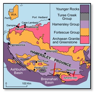
The Hamersley Province of Western Australia comprises a thick succession (up to 5-6 km) of largely volcanic rocks (Fortescue Group) overlain by a 2.5 km thick succession dominated by banded iron-formation units (Hamersley Group) (e.g. Harmsworth et al., 1990). The province contains an early Proterozoic foreland fold-and-thrust belt that hosts ten percent of known world reserves of iron ore. Renewed company interest in extending ore reserves requires knowledge of the subsurface structural geology, which will be gained by incorporating surface geological data with gravity, magnetic and seismic data. Data from two multi-channel seismic profiles obtained in 1997 (Figure 1) will constrain structural sections through the region, and gravity and magnetic measurements will be used to discriminate between possible alternative subsurface sections. Balanced structural sections across the fold-and-thrust belt will form the basis for an integrated model of the structural evolution of the Hamersley Province.
…
The longer of the two seismic lines, situated approximately 100 km west of Newman, begins in gently folded late Archaean to early Proterozoic Hamersley Group rocks close to the undeformed foreland and continues south into a fold belt dominated at all scales by north-verging asymmetric folds. The southern margin of the fold belt is bounded by a major normal fault that brings the younger sedimentary rocks of the late Paleoproterozoic Bresnahan Basin into contact with dolerites of the late Archaean upper Fortescue Group.
…
A shorter line, 20 km east of Newman, runs approximately 40 km north-south from Hamersley Group rocks that progressively become more intensely deformed to the south before crossing into the Sylvania Inlier (Figure 1). This Archaean granite-greenstone terrain is juxtaposed against the younger rocks of the Hamersley and Fortescue Groups, and the boundary is interpreted as a south-dipping fault contact involving over-thrusting of basement during formation of the fold-and-thrust belt (Tyler & Thorne, 1990; Tyler, 1991). Geophysical data along this seismic line provide important constraints for modelling the geometry of this important boundary.
![]()

